Spring 2024 Geospatial Workshop Survey Responses

Number of responses

Code
library(tidyverse)
library(bslib)
library(shiny)
library(bsicons)
source("scripts/helper_functions.R")

# list of workshop IDs to filter results
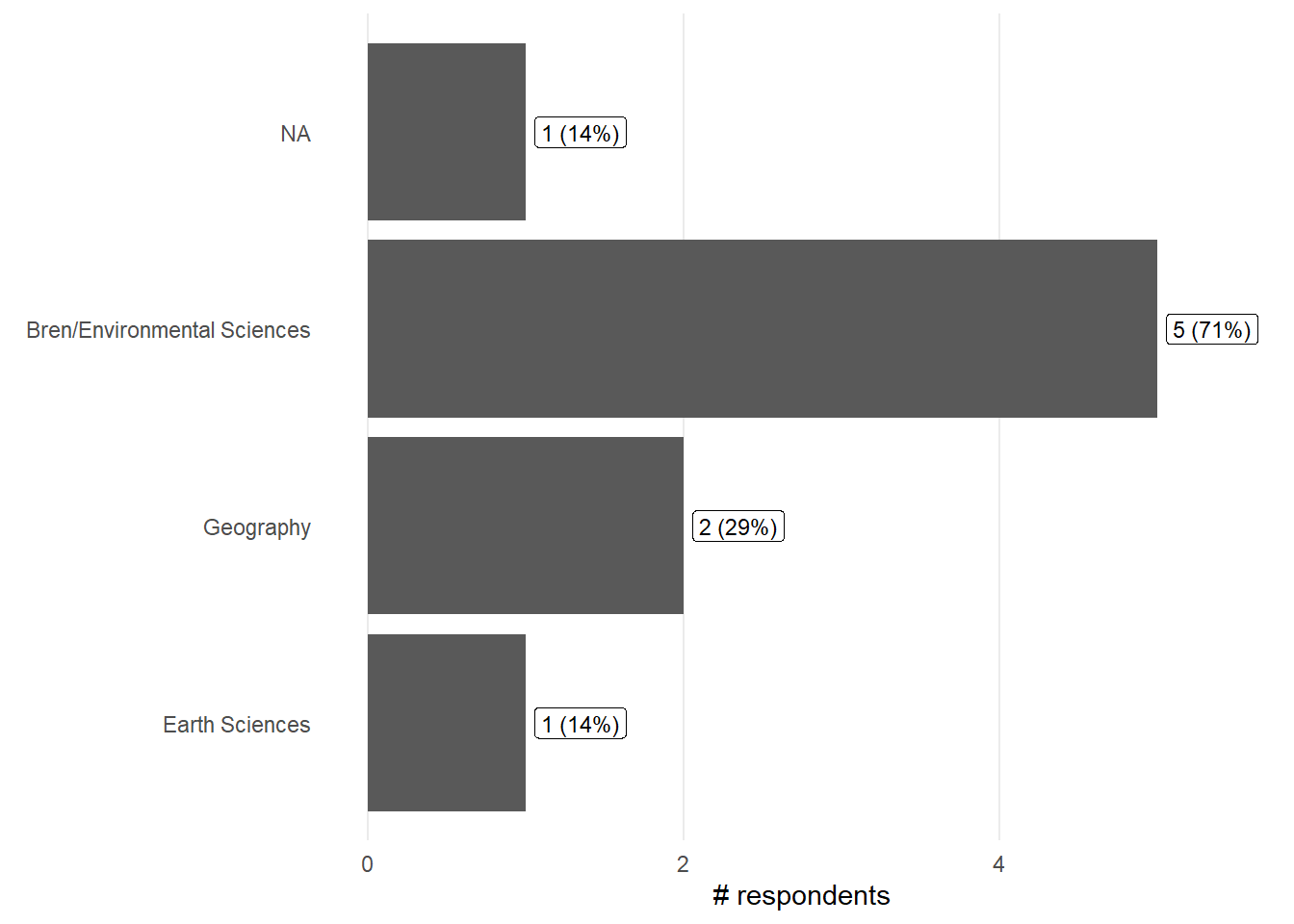
workshops <- c("2024-06-10-ucsb-geospatial")

results <- read_csv("data-joined/all_workshops.csv") %>% 
  filter(workshop %in% workshops)

pre_survey <- results %>%
  select(ends_with(".pre"))

post_survey <- results %>%
  select(ends_with(".post"))

n_pre <- sum(apply(post_survey, 1, function(row) all(is.na(row))))
n_post <- sum(apply(pre_survey, 1, function(row) all(is.na(row))))
n_total <- nrow(results)
n_both <- nrow(results) - n_pre - n_post

layout_columns(
  value_box(
    title = "Total responses", value = n_total, ,
    theme = NULL, showcase = bs_icon("people-fill"), showcase_layout = "left center",
    full_screen = FALSE, fill = TRUE, height = NULL
  ),
  value_box(
    title = "Both pre- and post-", value = n_both, , theme = NULL,
    showcase = bs_icon("arrows-expand-vertical"), showcase_layout = "left center",
    full_screen = FALSE, fill = TRUE, height = NULL
  ),
  value_box(
    title = "Only pre-workshop", value = n_pre, ,
    theme = NULL, showcase = bs_icon("arrow-left-short"), showcase_layout = "left center",
    full_screen = FALSE, fill = TRUE, height = NULL
  ),
  value_box(
    title = "Only post-workshop", value = n_post, , theme = NULL,
    showcase = bs_icon("arrow-right-short"), showcase_layout = "left center",
    full_screen = FALSE, fill = TRUE, height = NULL
  )
)

Total responses

8

Both pre- and post-

4

Only pre-workshop

3

Only post-workshop

1

Departments

Code
depts <- results %>% select(dept_select.pre) %>% 
  separate_rows(dept_select.pre, sep=",") %>% 
  count(dept_select.pre, name = "count") %>% 
  mutate(percent = (count / (n_total - n_post)) * 100,
         text = sprintf("%.0f (%.0f%%)", count, percent))

ggplot(depts, aes(y=reorder(dept_select.pre, count), x=count)) +
    geom_col() +
    geom_label(aes(label = text, hjust = -0.1),
               size = 3) +
    labs(x = "# respondents", y = element_blank()) +  
    theme_minimal() +
    theme(
      panel.grid.minor = element_blank(),
      panel.grid.major.y = element_blank()
      ) +
    expand_limits(x = c(0,max(depts$count)*1.1))

“Other” Departments

Code
other_depts <- results %>% 
  count(dept_other.pre, name = "count") %>% 
  drop_na() %>% 
  mutate(percent = (count / (n_total - n_post)) * 100,
         text = sprintf("%.0f (%.0f%%)", count, percent))

ggplot(other_depts, aes(y=reorder(dept_other.pre, count), x=count)) +
    geom_col() +
    geom_label(aes(label = text, hjust = -0.1),
               size = 3) +
    labs(x = "# respondents", y = element_blank()) + 
    theme_minimal() +
    theme(
      panel.grid.minor = element_blank(),
      panel.grid.major.y = element_blank()
      ) +
    expand_limits(x = c(0,max(other_depts$count)*1.1))
Warning in max(other_depts$count): no non-missing arguments to max; returning
-Inf

Current occupation / Career stage

Code
ocup <- results %>% select(occupation.pre) %>% 
  separate_rows(occupation.pre, sep=",") %>% 
  count(occupation.pre, name = "count") %>% 
  drop_na() %>% 
  mutate(percent = (count / (n_total - n_post)) * 100,
         text = sprintf("%.0f (%.0f%%)", count, percent))

ggplot(ocup, aes(y=reorder(occupation.pre, count), x=count)) +
    geom_col() +
    geom_label(aes(label = text, hjust = -0.1),
               size = 3) +
    labs(x = "# respondents", y = element_blank()) + 
    theme_minimal() +
    theme(
      panel.grid.minor = element_blank(),
      panel.grid.major.y = element_blank()
      ) +
    expand_limits(x = c(0,max(ocup$count)*1.2))

Motivation - Why are you participating in this workshop?

Code
motiv <- results %>% select(motivation_select.pre) %>% 
  separate_rows(motivation_select.pre, sep=",")  %>% 
  count(motivation_select.pre, name = "count") %>% 
  drop_na() %>% 
  mutate(percent = (count / (n_total - n_post)) * 100,
         text = sprintf("%.0f (%.0f%%)", count, percent))

ggplot(motiv, aes(y=reorder(motivation_select.pre, count), x=count)) +
    geom_col() +
    geom_label(aes(label = text, hjust = -0.1),
               size = 3) +
    labs(x = "# respondents", y = element_blank()) + 
    theme_minimal() +
    theme(
      panel.grid.minor = element_blank(),
      panel.grid.major.y = element_blank()
      ) +
    expand_limits(x = c(0,max(motiv$count)*1.2))

How did you find out about this workshop?

Code
findw <- results %>% select(findout_select.pre) %>% 
  separate_rows(findout_select.pre, sep=",")  %>% 
  count(findout_select.pre, name = "count") %>% 
  drop_na() %>% 
  mutate(percent = (count / (n_total - n_post)) * 100,
         text = sprintf("%.0f (%.0f%%)", count, percent))

ggplot(findw, aes(y=reorder(findout_select.pre, count), x=count)) +
    geom_col() +
    geom_label(aes(label = text, hjust = -0.1),
               size = 3) +
    labs(x = "# respondents", y = element_blank()) + 
    theme_minimal() +
    theme(
      panel.grid.minor = element_blank(),
      panel.grid.major.y = element_blank()
      ) +
    expand_limits(x = c(0,max(findw$count)*1.2))

What you most hope to learn?

Code
results %>% group_by(workshop) %>% 
  select(workshop, hopes.pre) %>% 
  drop_na()
workshop hopes.pre
2024-06-10-ucsb-geospatial ’- Expanding my data science skills ; - Learning to do things I do in ArcGIS in R
2024-06-10-ucsb-geospatial Despite being in a geography Ph.D. program, I have little experience with more technical aspects of spatial data (I’m honestly not too sure what vector and raster data are). One of the reasons I have’t learned these things is because I didn’t want to use a proprietary GIS software and didn’t really want to have a seperate set of analyses done outside of R. So, I hope to learn some key definitions and concepts and how to implement them in R.
2024-06-10-ucsb-geospatial looking forward to new ways of analyzing geographic data
2024-06-10-ucsb-geospatial Basic processing steps for working with spatial data! And a review of CRS, projections, and how R shows you that information
2024-06-10-ucsb-geospatial Geospatial analysis in RStudio

Learning environment in the workshop

Code
orderedq <- c("Strongly Disagree", "Somewhat Disagree", "Neither Agree or Disagree","Somewhat Agree", "Strongly Agree")
addNA(orderedq)
Code
agree_questions <- results %>% 
  select(join_key, agree_apply.post,    agree_comfortable.post, agree_clearanswers.post,
         agree_instr_enthusiasm.post, agree_instr_interaction.post, agree_instr_knowledge.post
) %>% 
  filter(!if_all(-join_key, is.na))

n_agree_questions <- nrow(agree_questions)
  
agree_questions <- agree_questions %>%
  pivot_longer(cols = -join_key, names_to = "Question", values_to = "Response") %>% 
  mutate(Response = factor(Response, levels = orderedq),
         Question = recode(Question,
                     "agree_apply.post" = "Can immediatly apply 
 what they learned",
                     "agree_comfortable.post" = "Comfortable learning in 
 the workshop environment",
                     "agree_clearanswers.post" = "Got clear answers 
 from instructors",
                     "agree_instr_enthusiasm.post" = "Instructors were enthusiastic",
                     "agree_instr_interaction.post" = "Comfortable interacting 
 with instructors",
                     "agree_instr_knowledge.post" = "Instructors were knowledgeable 
 about the material"
      ))

summary_data <- agree_questions %>%
  count(Question, Response, name = "count") %>% 
  mutate(percent = (count / n_agree_questions) * 100,
         text = sprintf("%.0f (%.0f%%)", count, percent))

ggplot(summary_data, aes(x = Question, y = count, fill = Response)) +
  geom_col(position = "fill", color = "black", show.legend = TRUE) +
  scale_y_continuous(labels = scales::percent_format()) + 
  scale_fill_manual(values = c("Strongly Disagree" = "#d01c8b", 
                               "Somewhat Disagree" = "#f1b6da", 
                               "Neither Agree or Disagree" = "#f7f7f7", 
                               "Somewhat Agree" = "#b8e186", 
                               "Strongly Agree" = "#4dac26"), 
                    na.translate = TRUE, na.value = "#cccccc", 
                    breaks = orderedq, drop = FALSE) +
  geom_text(aes(label = text), size = 3,
             position = position_fill(vjust = 0.5)) +
  labs(y = "# respondents (Percentage)", x = element_blank(), fill = "Responses",
       subtitle = paste0("Number of responses: ", n_agree_questions)) +
  theme_minimal() +
  theme(axis.text.x = element_text(angle = 45, hjust = 1),
        plot.subtitle = element_text(hjust = 0.5, size = 12))

How an instructor or helper affected your learning experience

Code
results %>% 
  group_by(workshop) %>% 
  select(workshop, instructor_example.post) %>%
  drop_na()
workshop instructor_example.post
2024-06-10-ucsb-geospatial I got so lost in the end and I have been using R for 6 years. The directions were unclear and the instructor just kept jumping around
2024-06-10-ucsb-geospatial talking through why we need to add certain lines of codes or use certain commands is extremely helpful
2024-06-10-ucsb-geospatial Helpful to do challenge questions to reinforce learning - would be better if they were a bit more challenging, rather than just repeating what we just did

Skills and perception comparison

Code
# Calculate mean scores and make graph for all respondents (only_matched=FALSE)
tryCatch(
  {
mean_nresp <- get_mean_scores_nresp(results, only_matched=FALSE)
graph_pre_post(mean_nresp$mean_scores, mean_nresp$n_resp_pre, mean_nresp$n_resp_post, mean_nresp$n_resp_pre_post, only_matched=FALSE)
},
error = function(cond) {
message("Could not do the plots as there are no pre or post results to show")
}
)

Code
# Calculate mean scores and make graph for only matched respondents in pre and post (only_matched=TRUE)
tryCatch(
  {
mean_nresp <- get_mean_scores_nresp(results, only_matched=TRUE)
graph_pre_post(mean_nresp$mean_scores, mean_nresp$n_resp_pre, mean_nresp$n_resp_post, mean_nresp$n_resp_pre_post, only_matched=TRUE)
},
error = function(cond) {
message("Could not do the plots as there are no pre or post results to show")
}
)

Workshop Strengths

Code
results %>% 
  group_by(workshop) %>% 
  select(workshop, workshop_strengths.post) %>% 
  drop_na()
workshop workshop_strengths.post
2024-06-10-ucsb-geospatial Accessibility
2024-06-10-ucsb-geospatial Good intro to lots of things
2024-06-10-ucsb-geospatial direct application for spatial plotting in R.
2024-06-10-ucsb-geospatial Beginner friendly, slow pace, easy to work with data
2024-06-10-ucsb-geospatial The lessons are clear and easy to follow

Ways to improve the workshop

Code
results %>% 
  group_by(workshop) %>% 
  select(workshop, workshop_improved.post) %>% 
  drop_na()
workshop workshop_improved.post
2024-06-10-ucsb-geospatial It’s more helpful to have the instructor walk through the lecture than than jumping around.
2024-06-10-ucsb-geospatial Streamline the second day
2024-06-10-ucsb-geospatial Good that we can plot vector and raster data, but making it look good with a basemap, good color palette, scale bar(?), north arrow(?), and line sizing would be more beneficial.
2024-06-10-ucsb-geospatial Go through a bit faster / cover more content. Or offer two sections (one for beginners and one for intermediate)
2024-06-10-ucsb-geospatial I think that people who have not worked with R before could benefit from a brief introduction on ggplot geoms and aesthetics

How likely are you to recommend this workshop? Scale 0 - 10

Code
orderedq <- c("Detractor", "Passive", "Promoter")

nps <- results %>% 
  count(recommend_group.post, recommende_score.post, name = "count") %>% 
  drop_na() %>% 
  mutate(recommend_group.post = factor(recommend_group.post, levels = orderedq),
         percent = (count/sum(count)) * 100,
         text = sprintf("%.0f (%.0f%%)", count, percent))

nps %>% 
ggplot(aes(x=recommende_score.post, y=count, fill=recommend_group.post)) +
  geom_col(color="black", show.legend = TRUE) +
  scale_fill_manual(values = c("Detractor" = "#af8dc3", "Passive" = "#f7f7f7", "Promoter" = "#7fbf7b"), breaks = c("Detractor", "Passive", "Promoter"), drop = FALSE) +
  geom_label(aes(label = text, vjust = -0.5), fill = "white", size= 3) +
  scale_x_continuous(breaks = 1:10) +
  labs(x = "NPS Score", y = "# respondents", subtitle = paste0("Number of responses: ", sum(nps$count), "
 Mean score: ", format(weighted.mean(nps$recommende_score.post, nps$count), digits = 3))) +
  theme_minimal() +
  theme(
    panel.grid.minor = element_blank(),
    panel.grid.major.x = element_blank(),
    plot.subtitle = element_text(hjust = 0.5, size = 12)
  ) +
  expand_limits(x = c(1,10),
                y = c(0, max(nps$count)*1.1))

Topic Suggestions

Code
results %>% 
  group_by(workshop) %>% 
  select(workshop, suggest_topics.post) %>% 
  drop_na()
workshop suggest_topics.post
2024-06-10-ucsb-geospatial plotting vector data over a raster RGB image, creating change maps of variables through time. I guess this would be more a more advanced spatial workshop.
2024-06-10-ucsb-geospatial text analysis?